


Naviator

Naviator açıklaması
This is a 30 day free trial of Naviator. Please see the "Subscription Information" section below for more details.
Notice: we do not provide customer support via Play Store reviews. Please contact our Support Team for customer support issues.
Naviator is a full-featured moving map GPS app for pilots. For less than the price of an hour of fuel you can have access to GPS navigation technology that would have cost thousands of dollars only a few years ago!
Quickly and easily share your flights with your friends on Naviator Hangar! (http://hangar.naviatorapp.com/)
FEATURES:
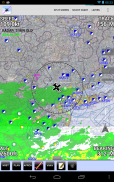
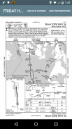
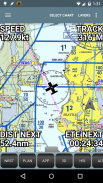
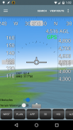
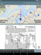
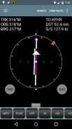
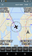
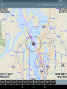
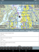
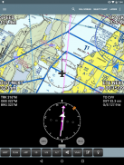
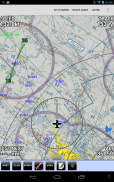
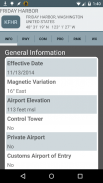
• GPS moving map with airspace, airports, radio navigation aids, airway intersections, TFRs
• All navigational data is downloaded to your device - no internet connection is required while you are flying
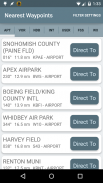
• Easy "rubber band" flight planning
• Support for ADS-B receivers including the iLevil AW/SW, Dual XGPS 170 and XGPS 190, Navworx, SkyGuardTWX, Flight Data Systems Pathfinder, Stratux, FlightBox, uAvionix pingBuddy and various receivers from FreeFlight Systems
• Integrates with ADS-B or the Zaon XRX for real-time traffic display
• NEW! AOPA members can import their stored routes from the AOPA Flight Planner
• NEW! Import custom airspace from OpenAir airspace files
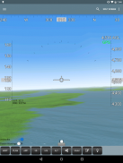
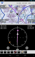
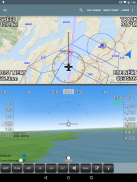
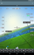
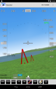
• 3D synthetic vision with terrain, obstacles/towers and runways
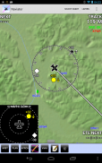
• Global terrain database with terrain warnings
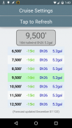
• Global Forecast Engine provides winds aloft anywhere on the planet up to 54,000 feet
• GPS track recording - upload your flight recordings to your own personalized Naviator Hangar (http://hangar.naviatorapp.com)
• Import routes from other flight planning systems using the GPX format
• Integrates with Microsoft Flight Simulator and Prepar3D
• Integrates with X-Plane using the "X-Plane to GPS" app (https://play.google.com/store/apps/details?id=com.appropel.xplanegps)
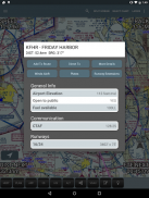
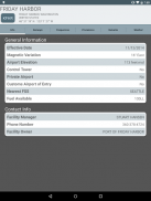
• Get a weather briefing and file a flight plan from right inside the app
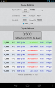
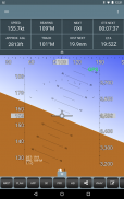
• Vertical navigation (VNAV) calculator
• Canadian data including airspace, airports, navaids, terrain and weather
• NMEA output - Naviator can drive your aircraft's autopilot
• "Bring Your Own Charts" - you can import custom maps and charts into the app. See our forum for more details.
Our support forum is located at http://forum.naviatorapp.com/
SUBSCRIPTION INFORMATION:
Subscriptions provide access to all app, chart and data updates for the duration of the subscription.
PRICING:
Naviator is free of charge for the first 30 days of use. After this free trial period, the following items may be purchased:
(a) 30 Day Chart Subscription - $4.99 USD
Enables full app access for 30 days*
(b) 1 Year Chart Subscription - $34.99 USD
Enables full app access for one year*
(c) Unlock Naviator - $14.99 USD
Intended for pilots who do not fly in the United States, this one-time charge permanently unlocks all features of Naviator, except FAA approach plates, sectionals, TACs, IFR enroute charts, TFR updates and the "BYOC" feature.
Includes database updates, weather updates, high-detail VFR base map, terrain database and 3D synthetic vision
* geo-referenced approach plates require an optional subscription from Seattle Avionics. See our website for details.
Bu Naviator bir 30 günlük ücretsiz deneme olduğunu. Daha fazla bilgi için aşağıdaki "Abonelik Bilgi" bölümüne bakın.
Uyarı: Biz Google Play Store değerlendirme yoluyla müşteri desteği vermemektedir. Müşteri destek konularında Destek Ekibi ile irtibata geçiniz.
Naviator pilotlar için tam özellikli bir hareketli harita GPS uygulaması olduğunu. yakıt bir saat fiyat daha az için sadece bir kaç yıl önce dolar maliyeti binlerce olurdu GPS navigasyon teknolojisi erişebilir!
Hızlı ve kolay Naviator Hangar arkadaşlarınızla uçuş paylaşın! (Http://hangar.naviatorapp.com/)
ÖZELLİKLERİ:
• hava sahasını, havaalanları, radyo navigasyon yardımları, havayolu kavşak, TFRS haritayı hareketli GPS
• Tüm seyir veri cihazınıza indirilir - hiçbir internet bağlantısı gerekli uçan ederken
• Kolay "lastik bant" uçuş planlama
• iLevil AW / SW dahil ADS-B alıcıları için destek Çift xgps 170 ve xgps 190 , Navworx SkyGuardTWX Uçuş Bilgi Sistemleri Pathfinder , <> Stratux FlightBox b, , uAvionix pingBuddy b FreeFlight Sistemleri
• ADS-B ile bütünleşir veya Zaon XRX gerçek zamanlı trafik ekran için
• YENİ! Üyeler AOPA Uçuş Planlayıcı'dan onların saklı güzergahları alabilirsiniz AOPA
• YENİ! OpenAir hava sahası dosyaları İthalat özel hava sahası
arazi, engellere / kule ve pist ile • 3D sentetik vizyon
• Arazi uyarıları ile Küresel arazi veritabanı
• Küresel Tahmin Motor 54.000 feet gezegende havada her yerde rüzgarlar sağlar
• GPS iz kaydı - Kendi kişiselleştirilmiş Naviator Hangar için uçuş kayıtları yüklemek (http://hangar.naviatorapp.com)
• GPX biçimini kullanarak diğer uçuş planlama sistemlerinin İthalat yolları
• Microsoft Flight Simulator ve Prepar3D ile bütünleşir
• "GPS X-Plane" kullanarak X-Plane ile bütünleşir uygulaması (https://play.google.com/store/apps/details?id=com.appropel.xplanegps)
• Bir hava brifing almak ve doğrudan uygulamanın içinden bir uçuş planını dosya
• Dikey navigasyon (VNAV) hesap makinesi
hava sahası, havaalanları, navaids, arazi ve hava olmak üzere • Kanadalı veri
• NMEA çıkışı - Naviator senin uçağın otopilot sürebilirim
• "Kendi Grafikler getir" - uygulamanın içine özel haritalar ve grafikler alabilirsiniz. Daha fazla bilgi için forum bakın.
Bizim destek forumu http://forum.naviatorapp.com/ yer almaktadır
ABONELİĞİ BİLGİLERİ:
Abone abonelik süresi boyunca tüm uygulama, grafik ve veri güncellemelerine erişim sağlar.
FİYATLANDIRMA:
Naviator kullanımının ilk 30 gün boyunca ücretsizdir. Bu ücretsiz deneme süresinden sonra, aşağıdaki öğeleri satın alınabilir:
(A) 30 Gün Grafik Abonelik - $ 4.99 USD
* 30 gün için tam bir uygulama erişimi sağlar
(B) 1 Yıllık Grafik Abonelik - $ 34,99 USD
* Bir yıl boyunca tam uygulama erişimi sağlar
(C) kilidini Naviator - $ 14.99 USD
Amerika Birleşik Devletleri'nde sinek yok pilotlar için Amaçlanan, bu tek seferlik şarj kalıcı FAA yaklaşım plakaları, yarışmalara, TAC, IFR enroute tablolar, TDH güncellemeleri ve "BYOC" özelliği dışında Naviator tüm özelliklerini açar.
veritabanı güncellemeleri, hava durumu güncellemeleri, yüksek detay VFR temel harita, arazi veritabanı ve 3D sentetik vizyon içerir
* Jeo-referanslı yaklaşım plakaları Seattle Aviyonik gelen isteğe bağlı bir abonelik gerektirebilir. Ayrıntılı bilgi için web sitemize bakınız.
Naviator - Sürüm 4.2.1
(12-11-2020)
Naviator - APK Bilgisi
APK sürümü: 4.2.1Paket: com.onetwentythree.skynavNaviator uygulamasının en son sürümü
Diğer sürümler


 4.15
4.15


Aynı kategorideki uygulamalar


